


The July heat is being replaced by April coolness
May, which heated the air to July values reaching +30 +31°C, has returned us to the more familiar +20 +25°C. And in the near future, the downward temperature trend will continue. Due to the influx of air masses from northern latitudes, daytime thermometers will fluctuate between +9 and +19°C, which would be more typical of April weather.
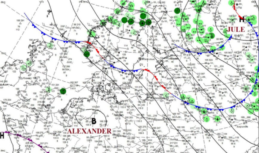
The culprit behind this cooling will be Cyclone JULE, which has settled over northern Europe. It will supply not only polar air but also, together with its companions – atmospheric fronts – new rounds of precipitation. At the same time, the cyclone will intensify and become a powerful barometric formation, its influence extending not only over a large part of the European territory of Russia (from the White Sea to the Black Sea) but also over a significant thickness of the atmosphere (up to 10 km). Under such conditions, even Anticyclone ALEXANDER will find it extremely difficult to displace its area of influence. In the current synoptic situation, barometric gradients will increase, leading to stronger winds from northern directions and creating additional discomfort from the foul weather.
Therefore, today, May 26, under the influence of the frontal sections of Cyclone JULE, brief localized showers will occur. Amid fluctuations in atmospheric pressure, winds will intensify in some places, and in many western regions of the republic, gusts will reach 15–18 m/s (an orange level of danger is in effect). Meanwhile, atmospheric fronts stretching across the central regions of the country divide it into a cool northeast and center, with temperatures of +15 +21°C, and a warm southwest, where the air will warm up to +25°C.
Over the next three days (May 27–29), unstable weather conditions will persist in Belarus.
May 27 (Wednesday) atmospheric fronts from Cyclone JULE will continue moving across the territory of our country. As a result, brief showers will occur at night in some areas, and during the morning and daytime across most of the territory; thunderstorms are possible in places. In the morning and daytime hours, with active atmospheric processes, wind gusts of 15–20 m/s are expected in many regions of the country (an orange level of danger has been declared). Due to the influx of cooler air, the temperature background will drop, ranging from +13°C in the north to +21°C in the south by midday.
May 28–29 (Thursday–Friday) Belarus will remain within cyclonic circulation, so rainy and windy weather will persist across the republic. At the same time, cold advection will intensify, the temperature background will drop further and will generally be 1–7°C below the climatic norm. Nighttime lows will be +2 +9°C, and daytime highs will range from +9°C in the north to +19°C in the southwest.
Later, from May 30 to June 1, the influence of the stormy cyclone will weaken. With rising atmospheric pressure and westerly flows, the weather will gradually improve: it will become warmer, the wind will die down, and there will be less rain.
When using the information a reference to Belhydromet is obligatory
Specialized sites
Informational resources
 State Symbols of the Republic of Belarus
 The National Legal Internet Portal of the Republic of Belarus
 The Ministry of Natural Resources and Environmental Protection of the Republic of Belarus
 The Official Internet Portal of the President of the Republic of Belarus
 The Portal for Rating Assessment of the Quality of Services Provided by Organizations in the Republic of Belarus
 The CIS Interstate Council for Hydrometeorology (CIS ICH)
 Information Analysis Portal of the Union State
 The Union State Committee on Hydrometeorology and Environmental Contamination Monitoring
 The Internet Portal "The Youth of Belarus"