


19.05.2023
Overview of hydrological situation of May 19, 2023

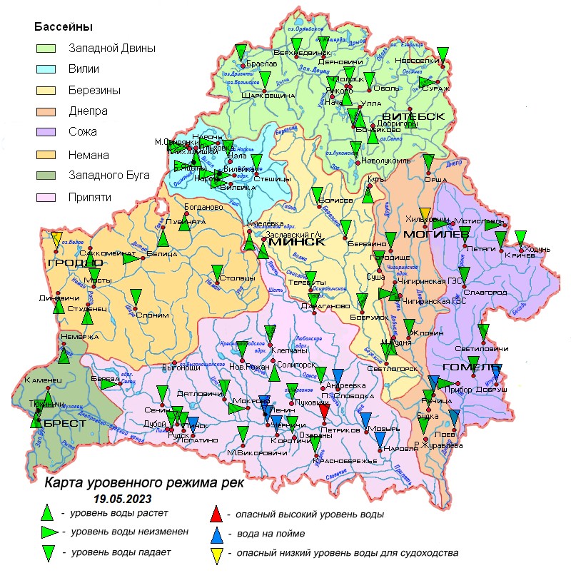
In the past period (May 16-18), on the Dnieper River near Zhlobin, Pina near Pinsk and Ubrati near Krasnoberezhye, the water entered the riverbed.
As of May 19 , the rivers mainly show a decline in water levels with a daily intensity of 1-18 cm .
On the Neman River near Grodno and the Dnieper River near Mogilev, water levels are below the marks limiting navigation.
Water levels exceed the water outlet marks on the Dnieper floodplain on the Rechitsa – Loev section, Pripyat on the Chernichi – Narovlya section, its tributaries the Styr, Sluch, Stviga, Ptich rivers, as well as the Sozh tributary the Iput River.
In Pripyat, near the town of Petrikov, the water level exceeds a dangerously high mark.
According to the Ministry of Emergency Situations, river flooding is observed in most districts of the Gomel region and the Vitebsk region of the Vitebsk region.
The water temperature in rivers and reservoirs has increased and is in the range from 10°C to 19°C.
In the next five days, the rivers will mainly experience a decline in water levels, as a result of which the water level in Pripyat near the town of Petrikov will drop below a dangerously high level. The water will enter the riverbed on the Dnieper at Rechitsa, Pripyat at Chernichi and Petrikov. On the Sozh near Slavgorod, the water level will drop below the dangerous low level limiting navigation, and near Krichev, it will approach it.
When using the information reference to Belhydromet is obligatory
Specialized sites
Informational resources
 State Symbols of the Republic of Belarus
 The National Legal Internet Portal of the Republic of Belarus
 The Ministry of Natural Resources and Environmental Protection of the Republic of Belarus
 The Official Internet Portal of the President of the Republic of Belarus
 The Portal for Rating Assessment of the Quality of Services Provided by Organizations in the Republic of Belarus
 The CIS Interstate Council for Hydrometeorology (CIS ICH)
 Information Analysis Portal of the Union State
 The Union State Committee on Hydrometeorology and Environmental Contamination Monitoring
 The Internet Portal "The Youth of Belarus"