


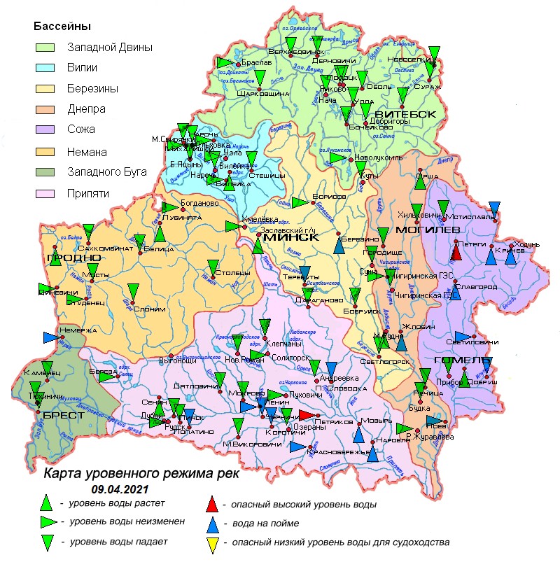
09.04.2021
Overview of hydrological situation of April 9, 2021
In the past day, on the Dnieper near the town of Zhlobin, the water reached the floodplain.
As of April 9, incomplete freeze-up remains on the Chigirinskoye reservoir, and residual banks on Lake Drivyaty.
The country's rivers are dominated by a decline in water levels and their even course. An increase in water levels with a daily intensity of 1-8 cm is observed throughout the Sozh, some parts of the Neman, Dnieper, Berezina and Pripyat. On the Neman near Grodno, the water level exceeded the mark limiting navigation.
The water is located on the floodplain on a tributary of the Western Bug to the Narev River near the village of Nemerzha, the Dnieper near the town of Zhlobin and the town of Loev, the Berezina near the town of Berezino, its tributary to the Svisloch River near the village of Terebuty, Sozhe near the town of Krichev and the town of Slavgorod, its tributaries the rivers Vikhra near the town of Mstislavl, Oster near the village of Khodun, Pronya near the village of Letyagi, Besed near the village of Svetilovichi and Iput near the town of Dobrush, Pripyat near the village of Chernichi, the town of Petrikov, the town of Mozyr and the town of Narovlya , its tributaries are the Styr rivers near the village of Lopatino, Sluch near the village of Lenin, Stviga near the village of Korotichi, Ubort near the village of Krasnoberezhye and Ptich near the village of 1st Slobodka.
Water levels exceed dangerous high marks: on Pripyat near the town of Petrikov by 4 cm, there is an even course of the water level; on the tributary of the Sozh River Pronya near the village of Letiagi by 6 cm, there is an increase in the water level with a daily intensity of 2 cm.
In the coming days, the rivers of the country will experience fluctuations in water levels with a downward trend, as a result of which the water level on the Berezina tributary, the Svisloch River near the village of Terebuty, will drop below the mark of water outlet to the floodplain.
 Official heraldic symbols of the Republic of belarus
 Internet portal of the President of the Republic of Belarus
 National legal Internet portal of the Republic of Belarus
 Ministry of natural resources and environmental protection of the Republic of Belarus