

When convective processes develop, a meteorologist cannot do without analyzing data from satellite monitoring and radar sounding, which make it possible to determine the presence of cumulonimbus clouds, their structure, characteristics – including the temperature of the cloud top – as well as associated convective phenomena (thunderstorms, heavy downpours, squalls).
Belarus's radar sounding network includes 5 modern Doppler weather radars (DWRs) installed in Minsk, Brest, Grodno, Vitebsk, and Gomel, with a coverage radius of 200 km each, which allows radar observations to cover virtually the entire territory of our country.
The DWRs scan the sky around the clock and make it possible to look inside clouds to detect the birth of hazardous phenomena. With the help of radars, meteorologists can:
- monitor the movement of cloud formations and cloud growth in near-real time (every 10 minutes);
- detect convective cells (powerful cumulonimbus clouds) associated with thunderstorms, hail, heavy downpours, and squalls.
Although squalls are among the most difficult phenomena to forecast, radars provide a crucial advantage – they allow the approach of such convective phenomena to be detected 1-3 hours in advance.
On a radar image, a squall appears as a bow-shaped curved band (Bow Echo) or a sharp line with a "ragged" edge. Most often, these are elongated, well-defined bands of extremely high reflectivity (from 45 to 60 dBZ and above), moving in the same direction. The leading edge of such a band is sharp and smooth; it is precisely there that the outflow of cold air occurs, causing the squall. The squall line moves very quickly (up to 60-80 km/h).
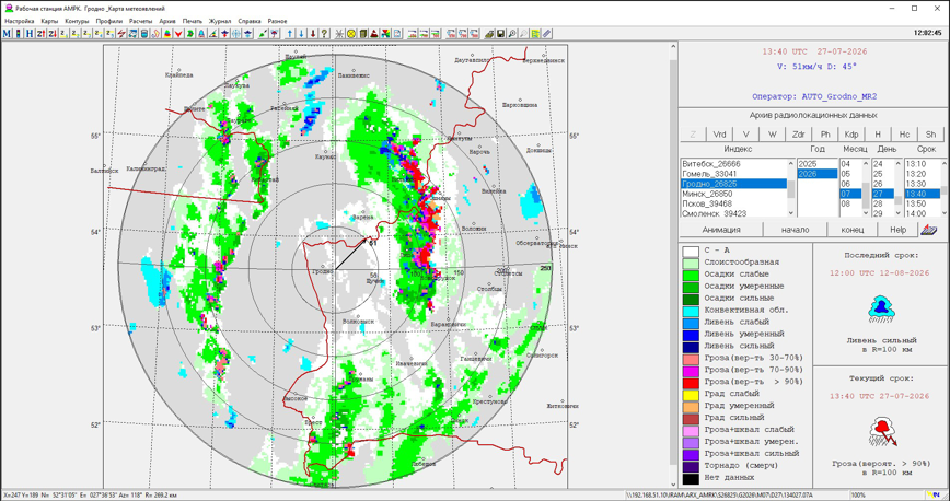
On DWR imagery, one can see how the arc bends forward, with its center (the apex of the arc) being the most dangerous spot, where the wind is strongest.
Having detected such a pattern, the meteorologist understands that near the ground, wind gusts are likely to exceed 25 m/s, and there are grounds for issuing a storm warning for a hazardous hydrometeorological phenomenon.
All convective processes develop within minutes. To predict large hail and supercell thunderstorms, meteorologists also look at the height of the cloud top – if it penetrates the tropopause and reaches 12-15 km, then adverse and hazardous hydrometeorological phenomena can be expected.
When using the information a reference to Belhydromet is obligatory
© Belhydromet, 2016-2026